
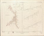
Plan and profile of Dungeness River, Washington
| Origin/Agency/Author: | Geological Survey (U.S.) |
|---|---|
| Publisher: | [Washington, D.C.] : U.S. Dept.of the Interior, Geological Survey |
| Date: | 1947 |
| Size: | 2 maps on 1 sheet; sheet 56 x 71 cm. |
| Condition: | Good |
| Note: | Map loaned to the State Library for digitization by the Museum and Arts Center in the Sequim-Dungeness Valley |
| Location: |
Museum and Arts Center in the Sequim-Dungeness Valley For complete citation |
| View Map: | JPEG |