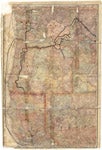
Map of Oregon and Washington Territory, 1882

| Origin/Agency/Author: | Rand McNally and Company |
|---|---|
| Publisher: | [Oregon? ]: Issued by the Oregon Railway & Navigation Co. ; Chicago : Rand, McNally & Co. |
| Date: | 1882 |
| Size: | 68 x 45 cm. |
| Condition: | |
| Note: | |
| Location: |
State Library For complete citation |
| View Map: | JPEG |


